 www.geodatenkatalog.de (S2F)
Keyword
South China Sea
7 record(s)
Provided by
Type of resources
Topics
Keywords
Contact for the resource
-
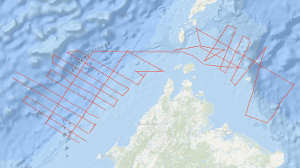
In the scope of International Geoscientific Programs and in close cooperation with PETRONAS, Malaysia, and in agreement with the Bureau of Mineral Resources (BMR) and the Bureau of Energy Development (BED), Manila, the Federal Institute for Geosciences and Natural Resources (BGR) carried out a geophysical survey on the continental margin off Sabah during the period from 20th July to 10th August, 1986, and in the Northwestern Sulu Sea during the period from 12th August to 28th August, 1986, using the PRAKLA-SEISMOS vessel EXPLORA chartered by the BGR. The research cruise is a continuation of BGR’s marine geoscientific studies in the South China Sea and in the Sulu Sea with the German research vessels VALDIVIA (1977), SONNE (1982/83) and EXPLORA (1984). The previous investigations provided new information regarding the geological and tectonic history of the southern part of the South China Sea in the context of plate tectonics. According to the interpretation of the large amount of geophysical, geological and geochemical data collected by BGR on previous cruises the widely accepted hypotheses of the presence of an ancient subduction zone beneath the Sabah-Palawan Trough has to be revised. The main objective of the EXPLORA cruise was to search for an Oligocene-Early Miocene carbonate platform off Sabah and in the western Sulu Sea. On the continental margin off Sabah 27 lines were surveyed with gravity and multichannel reflection seismics and partly with magnetics, with a total length of 3,126 km. A strong reflector interpreted as reflector BLUE of previous BGR cruises off Palawan was recognizable beneath the Sabah Trough in depth between 4 and 7 sec (TWT). The isochrones of the reflector strike approximately 50°N. The surface of the reflector dips with 2 to 3 degree towards southeast. Toward the north-western part of the Sabah Trough the reflector is disrupted by a basement high. According to the preliminary interpretation of the gravity data, the prominent free-air anomaly associated with the Sabah Trough and adjacent areas has the same shape as the anomaly observed across the Palawan Trough. Therefore it is concluded that the Sabah Trough is underlain by a thinned continental crust.
-
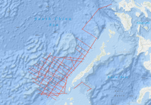
The aims of cruise SO197 RISE (Rift Processes in the South China Sea) with RV SONNE from Manila, 28th March 2008 to Singapore, 2nd May 2008 are (1) To gain a better understanding of the processes leading to continental breakup and subsequently formation of oceanic crust. (2) To study the evolution of the South China Sea oceanic basin. The South China Sea is particularly well suited for studying rift processes at the transition from extension of continental lithosphere to the formation of oceanic crust. This relatively young marginal basin is currently in a stadium which is characterised by still preserved differences in subsidence and thermal history resulting from rifting. The initial, complex and hardly quantifiable rift processes, however are long enough ago. The area under study comprises the eastern subbasin of the South China Sea, the West Luzon Basin and the transition area from oceanic crust to extended continental crust between the continental blocks of Reed Bank and the islands of Palawan/Calamian Group. By including existing data of earlier cruises (SO-23, -27, -49) a comparison of conjugated margin transects is intended later within the project. A major goal of the project is to study structures at the transition from continental rifting to oceanic spreading and processes resulting from extension of continental lithosphere to the formation of oceanic crust in time and space. The sequence stratigraphy of the synrift and drift sediments will give insights into the formation and evolution of the individual rift basins. The distribution and thickness of the postrift sediments on the continental fragment of the NW Palawan area define the subsidence history. The depth and topography of the Moho show the location of the stretched and thinned crust. By a joint interpretation of the structural setting, the position, distribution and architecture of the basin bounding faults a reasonable rift model will be derived. In addition, we will investigate the transition of a passive rifted margin (off Palawan) to a convergent margin (off Luzon). The timing of the evolution of the South China Sea basin will be more exactly determined by comparing the magnetic anomalies from the eastern subbasin of the South China Sea with existing data from the central/western basin. Particularly the question of a symmetric/asymmetric opening of the oceanic basin and the timing and location of the individual rift/drift episodes will be investigated. Therefore, we investigated rift structures at the southeastern margin of the South China Sea by means of reflection seismology, gravity, magnetics, bathymetry and sediment echosounder and we performed magnetic measurements to identify seafloor spreading anomalies in the eastern subbasin of the South China Sea.
-
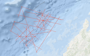
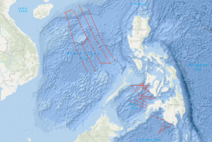
As recommended by the Joint CCOP-IOC Working Group on Post-IDOE Studies on East Asia Tectonics and Resources and the proposal of the Bureau of Mines and Geosciences of the Philippines to extend the research of the previous R/V SONNE survey SO-23, the Federal Institute of Geosciences and Natural Resources (BGR) carried out a geophysical survey in the southeastern part of the South China Sea (Dangerous Grounds) and in the northwestern part of the Sulu Sea in two legs from 29th April to 29th June 1983 on SONNE cruise SO-27. Multichannel reflection seismic measurements were carried out in parallel with magnetic, gravimetric, Sea-Beam, and 3.5 kHz subbottom profiler measurements on 34 lines with a total length of 7,204 km. In addition, 26 lines with a total length of 2,800 km were surveyed with only the last four named methods. SONNE cruise SO-27 was financed by the Federal Ministry of Research and Technology (BMFT). Six seismic sequences (DG-1 to DG-6) (DG = Dangerous Grounds) could be distinguished in the surveyed part of the South China Sea. The oldest recognizable sequence is the sequence DG-6, an equivalent of the Pre-Nido Formation of the northwest shelf of Palawan. Seismic unconformity Violet marks the top of the DG-6 sequence, which consists of a complex system of tilted horsts and half-grabens. The half-grabens are presumably filled with clastic sediments of Eocene age (seismic sequence DG-5). The top of seismic sequence DG-5 is bounded by unconformity Blue, which is interpreted as representing the end of the rift phase and the onset of seafloor spreading in the South China Sea about 32 m.y. ago. The overlying seismic sequence DG-4 is characterized by an internal reflection pattern with low frequencies. Lithologically, this sequence consists of shallow-water carbonates with reef complexes of Oligocene to Early Miocene age and has to be regarded as equivalent to the oil-containing Nido Formation of the Palawan shelf. A rapid subsidence of large parts of the survey area during the late (?) Early Miocene ended the growth of the shallow water carbonate platform, indicated by the unconformity Blue. The overlying seismic sequence DG-3 is interpreted as consisting of a transitional facies between a shallow water and a bathyal depositional environment. The top of this sequence is marked by unconformity Red, which most probably represents the end of the drifting phase (seafloor spreading) in the South China Sea during the Middle Miocene. The most prominent structural feature of the shelf and slope of central and southern Palawan is a thick sedimentary wedge originally interpreted as a melange. Our data show that the Oligocene to Early Miocene carbonate platform of the Dangerous Grounds extends beneath the Palawan Trough, as well as beneath the central and southern Palawan shelf, underlying the melange. Based on the finding that i) Rhaeto-Liassic rocks are present in the Dangerous Grounds, ii) the Oligocene to Early Miocene carbonate platform continues from the Dangerous Grounds through the Palawan Trough to the central and southern Palawan shelf, and iii) there is thinned continental crust 20 km thick below the continental slope of southern Palawan, we believe the Dangerous Grounds, together with Palawan and the Caiman Islands belong to a uniform continental fragment which separated from the proto-chinese continental margin when the South China Sea opened during the Oligocene. Previously, the melange of central and southern Palawan, which contains ophiolites, was interpreted as being autochthonous. In our opinion, the melange is an allochthonous mass which has been overthrusted onto the eastern margin of the Dangerous Grounds-Palawan-Caiman microcontinent from the Northwest Sulu Basin. The Ulugan Bay fault is interpreted as the northeastern front of this allochthonous mass. The area of prospective carbonate plays is considerably enlarged by the discovery that the Oligocene to Early Miocene carbonate platform with Nido-type reef structures extends below the allochthonous sediments of central and southern Palawan. We expect that hydrocarbon-bearing structures of the Sabah-type, i. e. thick, folded Neogene sediments, will be found in the western part of the northwestern Sulu basin. If our interpretation is correct, a new chapter of hydrocarbon exploration may be about to begin around Palawan in the Philippines.
-
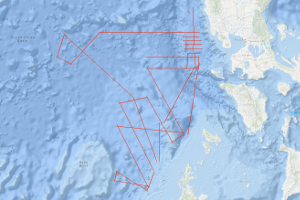
The main objectives of the BGR cruise BGR01 POPSCOMS (Properties of a Gas Hydrate Province on a Subduction-Collision Related Margin off Sabah) off Sabah/Malaysia with M/V AKADEMIK NEMCHINOV from 4th November to 3rd December 2001 in co-operation with PETRONAS Malaysia are the research on (1) Marine Methane Gas Hydrates: Detection, distribution and formation; relation to the adjacent highly productive "conventional" gas province in the specific tectonic setting of the collisional belt off Sabah. (2) Tectonic development of the (accretionary) margin off Sabah: Improve the tectonic stratigraphic hypothesis of the subducted Proto-South-China-Sea and continental crust under the accretionary wedge, respectively in the subducted plate. Open questions and targets of the survey: Within the help of the already existing magnetic data and other seismic measurement methods (e.g. special refraction seismic with ocean-bottom hydrophones [OBH], which presumably is an exellent and adequate method) we try to discern between oceanic and continental crust in the subducted plate, to investigate the nature of the transition and get information on the subduction angle. This is important in relation to the Cagayan Ridge (Sulu Sea) that is interpreted as an island arc that is related to the subduction of the proto-South China Sea. Another aim was to enable the determination of seismic anisotropy, distribution of BSR's and hydrates in the area and their v(p) to v(s) ratios. Are the gas hydrates related to the adjacent highly productive "conventional" gas province? What is the structural character of the transition zone between the hydrate province and the adjacent conventional gas bearing province further up-slope? Conversely, are there indication for a possible deepwater source? Can initial conclusions be drawn regarding their biogenic or thermogenic origin? Is there an impact of sedimentation conditions, compressional behaviour (e.g. at active margins) and/or structural properties on the genesis and stability of gas hydrates and BSRs (Bottom Simulating Reflectors)? How do the findings under different conditions compare in that regard? Which are the favorable conditions for the genesis of gas hydrates, and can they be detected by geophysical methods even if there are no BSR's? The findings are expected to provide a contribution to the assessment of the deepwater hydrocarbon potential along the continental margin off Sabah. Results: In the study area the BSRs were identified on the base of their polarity reversal with respect to the seafloor and when they transect reflectors from the strata. The widely distributed BSRs along the seismic lines of the survey deliver an indirect indicator for the presence of gas hydrates in the study area (BSR's in post Miocene sediments). The BSR depths below seafloor vary between 250 and 350 m. Differences in the reflection coefficient of the BSRs are mainly related to the amount of free gas beneath the Gas Hydrate Stability Zone.
-
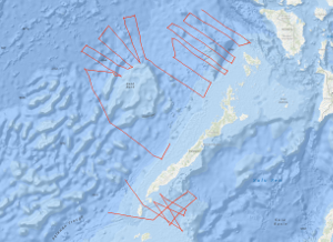
In the southwestern part of the Sulu Sea and in the southeastern part of the South China Sea, between NW Palawan and the northwestern part of the Reed Bank the Federal Institute for Geosciences and Natural Resources (BGR), Hannover carried out the geophysical survey BGR84 from 11th October, 1984 to 23rd November, 1984. This work was done in close cooperation with the Bureau of Mines and Geosciences (BMG), Manila, using the German seismic vessel EXPLORA chartered from PRAKLA-SEISMOS GmbH, Hannover. Multichannel reflection seismic measurements were carried out on 40 lines with a total length of 4,467 km simultaneously with magnetic measurements on 19 lines with a total length of 3,047 km. The Oligocene to lower Miocene Nido-carbonates of the South China Sea that have been proven during the SONNE cruises SO-23 and SO-27 beneath the allochthonous and chaotically deformed complex which was overthrusted from the Sulu Sea terrane, could be correlated up to the Balabac Straits. The three major unconformities of the Sulu Sea, unconformity A (Early Pliocene), unconformity B (mid Middle Miocene) and unconformity C (lower Middle Miocene) have been correlated over extensive areas by tying into the Sulu Sea well Coral-1. In the Sulu Sea reflection horizon C forms the top of a chaotic bedded rock complex and presumably represents an equivalent to the unconformity "Red" of the South China Sea, in the west of Palawan. There, the unconformity "Red" forms the surface of a highly deformed rock complex which has been interpreted as an allochthonous mass accumulation (HINZ, 1983; HINZ & SCHLÜTER, 1985). It is assumed that pronounced magnetic anomalies, approximately 140 - 160 km off NW Palawan as well as a change in the reflection seismic pattern of the acoustic basement, associated with diapiric structures which are interpreted as intrusions represent the ocean-continent boundary in this part of the South China Sea. In the Reed Bank area the basement type which is interpreted as continental crust (transitional crust?) extends as far as 160 km to the northwest, towards the South China Sea Basin. The northern part of the Reed Bank is characterized by intense downfaulting and rotated fault blocks with reef complexes ontop. In contrast to results from the Dangerous Grounds of the previous SONNE cruises, the deeper lying coherent reflections could be recognized in the monitor records off the northwestern Reed Bank area. It might be that these parts of the Reed Bank block consists of metamorphized and/or highly consolidated rocks of pre-Tertiary age which originally formed part of the Chinese back country, and which was effected by previous orogenies prior to the rifting of the proto-China continental margin.
-
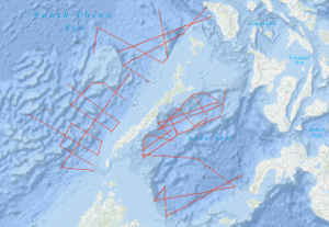
In the framework of the IDOE-SEATAR (International Decade of Ocean Exploration - Studies of East Asia Tectonics and Resources) Program, the Federal Institute for Geosciences and Natural Resources carried out a geophysical survey in the Sulu Sea during the period from March 11, 1982 to April 15, 1982 using the German research vessel R/V SONNE. The SONNE cruise no. SO-23 continued SEATAR-related studies of BGR which have been carried out during the Southeast Asian Cruise of the VALDIVIA (VA-16) in 1977. During SONNE cruise no. SO-23, multi-channel reflection measurements were carried out in parallel with magnetic, gravimetric, and sea-beam measurements on 21 lines with a total length of 3,300 km in the Sulu Sea. In the NW Sulu Basin, situated between the shelf of East Palawan in the north and the volcanic Cagayan Ridge in the south, a 50 - 100 km wide graben-like basin exists which is filled with thick Neogene and pre-Middle Miocene sediments. The basin trends east-northeast. At longitude 119°E it bends to a north-south direction. The dominating structural element within the sedimentary graben-like basin is a diapiric-chaotic zone about 25 km wide, which was only detectable west of longitude 120°E. The base of the elongated diapiric-chaotic zone, which might represent a tectonically mobilized equivalent of the Crocker Formation (Middle Miocene - Lower Oligocene) is difficult to define in the seismic monitor records. The configuration and the internal structural style of individual structures of the diapiric-chaotic zone, which can be followed over length of about 150 km, seem to resemble those of the oil-bearing province offshore western Sabah. In the eastern part of the NW-Sulu Basin east of longitude 119°E, several north-trending anticlines of presumably Middle Miocene age and locally volcanic intrusions of presumably Plio-Pleistocene age have been observed. During the second leg of the cruise SO-23 in the southeastern part of the South China Sea (April 16, 1982, to May 9, 1982) multi-channel seismic reflection measurements were carried out in parallel with magnetic, gravimetric, and sea-beam measurements on 19 lines with a total length of 3,570 km in the southeastern part of the South China Sea, including the area of the Dangerous Grounds. In addition, 2,280 km of profile was surveyed with only magnetics, gravity, and sea-beam measurements. A complex structural style was observed in the investigated part of the Dangerous Grounds, South China Sea, which is believed to be part of a microcontinental block which rifted from the continental margin of Asia in the Early Paleogene/Late Mesozoic time. There are prospective depocenters and structures trending NE-SW, E-W, and N-S in the southwestern part, i.e. the area west of longitude 117.5°E (units 2, 3, 4). Unit 4 contains a series of half-grabens with thick sedimentary infill. An imbricated melange of pre-Middle Miocene age seems to exist only off southern Palawan. The dominating structural trend in the area northeast of Reed Bank is NW-SE. Oceanic crust characterized by NW-trending magnetic lineations (anomalies 8 to 12 ?) was observed north of latitude 12°N and between longitude 118°E and the Manila Trench.
-
The SONNE cruise SO-49/1 from 6th April to 7th May 1987 was designed to investigate the Cotabato subduction zone off Mindanao and the geological structure of the eastern part of the Sulu Sea including the convergent continental margins off Zamboanga Peninsula, Negros, and Panay by a geophysical survey. On the 1st leg multichannel seismic reflection measurements were carried out in parallel with magnetic, gravimetric, sea beam and 3.5 kHz subbottom profiler measurements on 16 lines with a total length of 2,700 km. The SONNE cruise SO-49/1 was financed by the Federal Ministry of Research and Technology (BMFT). The geophysical survey in the Celebes Sea and in the Sulu Sea was carried out as a co-operative project by the Federal Institute for Geosciences and Natural Resources (BGR), the Bureau of Mines and Geoscience (BMG) and the Bureau of Energy Development (BED). 16 German scientists and technicians and 4 Philippine scientists attended SONNE cruise SO-49/1. The seismic lines surveyed across the Cotabato Trench/Celebes Sea and the Sulu Trench/Sulu Sea illustrate the active deformation of the layered sediments of the Celebes Sea and the SE Sulu Basin along the trenches: The seismic data suggest an active development of imbricate thrust sheets at the toe of the accretionary wedges and a simultaneous duplex-kind shortening within the wedges above the downgoing oceanic crust of the Celebes Sea and the SE Sulu Basin. The surface of the downgoing oceanic crust forms a major detachment plane or sole thrust. By these processes mass is added to the accretionary wedges resulting in thickening and growing of the wedges. The sedimentary apron overlaying the wedge is only mildly affected by these processes because the surface of the accretionary wedges forms a roof thrust. The collected geophysical data suggest that the oceanic SE Sulu Basin previously extended northward into Panay Island. It was closed by eastward subduction of oceanic crust beneath the upthrusted/updomed Cagayan Ridge. The Negros Trench, a 4.000 to 5,000 m deep bathymetric depression, is thought to represent the collision suture of the opposed subduction systems. The Cagayan Ridge which divides the Sulu Sea into the NW Sulu Basin and the SE Sulu Basin continues into the Antique Ridge of Panay. Approximately 45 suitable and problem-oriented sampling locations have been defined and documented for the subsequent geological and geochemical program by on-board analysis and interpretation of the seismic near trace records and the recordings of the 3.5 kHz subbottom profiler and the sea beam system. On cruise SO49/2 from 10th May to 21st June 1987, the research vessel SONNE of the Federal Republic of Germany undertook geoscience cruises in the South China Sea. The multidisciplinary study of the tectonic and natural resources of the region was a cooperative project between the Federal Institute for Geosciences and Natural Resources (BGR) and the Second Institute of Oceanography (SIO) in the frame of the Agreement between the State Oceanic Administration of the People's Republic of China and the Federal Ministry for Research and Technology of the Federal Republic of Germany on Cooperation in Marine Science and Technology. The first part of cruise SO49/2 was primarily to acquire multichannel seismic data, together with gravity, magnetic, sea beam, and 3.5 kHz measurements, and consisted of 4,112 km of traverses across the deep eastern and western sub-basins of the South China Sea from the Dangerous Grounds to the Chinese continental margin. The observed complex crustal deformation in the Southwestern South China Sea basin and in particular deep intracrustal reflection suggest a large-scale simple-shear kinematic mechanism for the development of at least the western sub-basins. The second part of cruise SO49/2 had primarily geological, geochemical and geothermal objectives and 21 dredge stations, 17 geochemical stations and 6 heat flow stations were carried out. The aims of the sampling were firstly to determine the lithologies and ages of the seismic sequences, and secondly to collect unconsolidated sediments for geochemical study of sorbed hydrocarbon gases in combination with heat flow measurements. Late Oligocene shallow-water carbonates dredged from 700 m to 2700 m of water depth indicate a strong subsidence of the investigated area. The underlying basement consists of continental crust with basaltic intrusions. The hydrocarbon gases of the outer continental slope originated by thermogenic processes from source rocks with a predominantly high maturity of the organic substances.